
A title plan is an official map from HM Land Registry that outlines a property's boundaries. While it doesn’t provide precise measurements, it helps homeowners, buyers, and solicitors understand property layouts and ownership rights. In this guide, we'll deep dive into everything you need to know about title plans.
What is the purpose of a title plan?
A title plan is an official document from HM Land Registry that provides a visual representation of a property’s boundaries. It plays a key role in property transactions, legal disputes, and land ownership rights. While it doesn’t give precise boundary measurements, it offers an important reference for homeowners, buyers, and solicitors.
- Defining property boundaries: It outlines the approximate extent of ownership, helping to prevent boundary disputes.
- Supporting property transactions: When buying or selling a property, a title plan helps buyers, solicitors, and mortgage lenders understand the land included in the purchase.
- Resolving boundary disputes: If there’s a dispute with a neighbour over a fence, wall, or access route, the title plan can serve as an important reference in legal discussions.
- Clarifying land rights: Some title plans show important rights and restrictions, such as shared access routes, easements, and land use limitations.
- Helping with planning applications: If you plan to extend your property, build an outbuilding, or make significant changes, your local authority may require a copy of the title plan as part of the planning application process.
What does it include?
A title plan typically contains:
- A map of the property: The property boundary is usually outlined in red to indicate the land included in the title.
- General boundaries: These show the approximate edges of the property but do not give precise measurements.
- Nearby properties and land features: Title plans show adjacent properties, roads, pathways, and landmarks to help provide context.
- Rights and restrictions: Some title plans include easements, access rights, or covenants affecting the land, such as shared driveways or public footpaths.
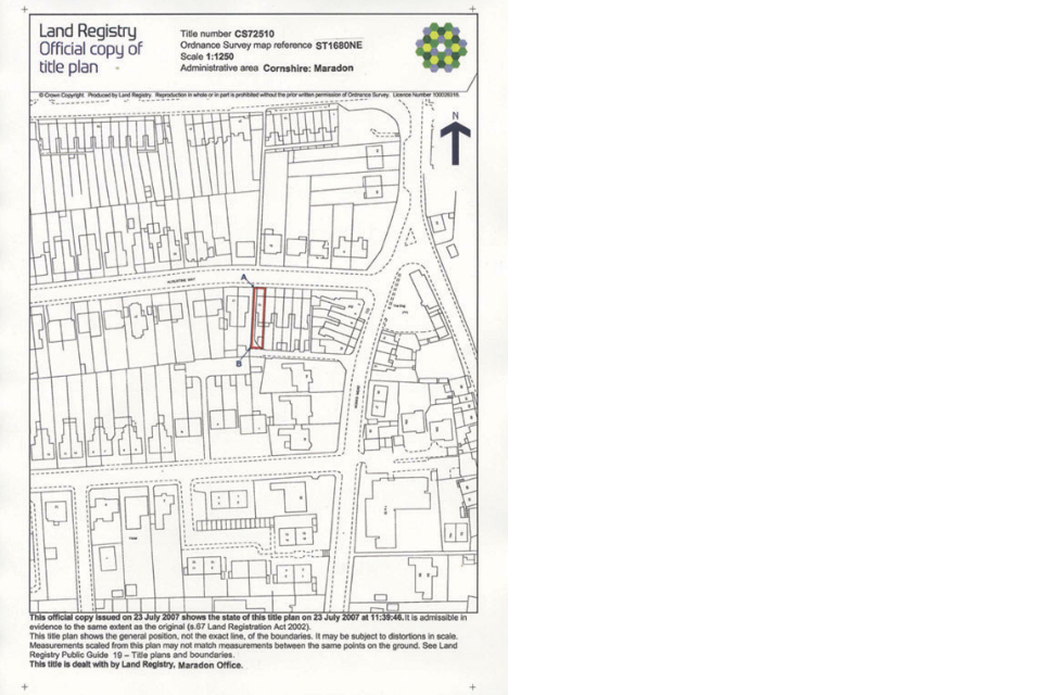
(Source: Gov.UK)
On a title plan, the land you own is outlined in red. Here’s what the markings mean:
- A solid black line means the boundary follows a physical feature like a fence or wall.
- A dashed black line means there’s no visible boundary on the ground.
- Green hatching highlights any separate pieces of land included in the property.
- Other colours? Check the title register - it’ll explain what they mean.
Is the title plan the same as title deeds?
No, a title plan and title deeds are different documents. Title deeds are historical records that prove ownership and detail past transactions, legal obligations, and restrictions affecting the property. Title plans are visual maps that show approximate property boundaries and surrounding features.
Can a title plan prove property ownership?
A title plan alone does not prove ownership. It only shows boundaries and layout. To legally prove ownership, you need a title register from HM Land Registry. The title register provides official confirmation of who owns the property and includes any legal charges or restrictions.
What is a title register?
A title register is a legal document that provides key details about a property, including:
- Owner details: The name(s) of the registered property owner(s).
- Purchase price history: If available, it may show how much the property was last sold for.
- Legal restrictions and covenants: Any conditions affecting how the property can be used.
- Mortgage or financial charges: Details of any outstanding loans or lender interests.
Need a copy of your title register? You can request one from HM Land Registry for a small fee to confirm property ownership and check for any restrictions.
Different types of title plans explained
When you request a title plan from HM Land Registry, you may come across different formats depending on when the plan was created and how it has been stored. These formats include vector title plans, raster title plans, and drawer/canister title plans. Each type serves the same purpose - showing a visual representation of a property’s boundaries - but they differ in how they are produced and presented.
Vector title plan
A vector title plan is the most modern and precise format used by HM Land Registry.
- Digitally created for accuracy and clarity.
- Scalable, meaning details remain sharp when zoomed in or printed at different sizes.
- Typically used for recently registered properties or when a title plan has been updated.
Best for: Those needing a clear, high-quality digital title plan with accurate boundary details.
Raster title plan
A raster title plan is an older format originally drawn by hand and then scanned into a digital image.
- Fixed-resolution image that cannot be scaled without losing clarity.
- Used for properties that were registered before HM Land Registry switched to vector mapping.
- Less detailed than vector plans but still legally valid.
Best for: Older properties where the title plan was created before digital mapping.
Drawer/canister title plan
A drawer or canister title plan refers to title plans that have been stored physically rather than digitally.
- Usually found in older, unregistered properties or records predating digital storage.
- Often hand-drawn or printed on paper and kept in HM Land Registry’s archives.
- May require manual retrieval and scanning if needed.
Best for: Properties that have not been digitised yet, or cases where historical property information is required.
How to get a copy of a title plan
If you need to check the title plan for a property, you can get a copy from:
- HM Land Registry: You can purchase a digital or paper copy online for a small fee.
- Your solicitor or conveyancer: If you’re buying or selling a property, a UK property solicitor may provide a copy as part of the transaction process.
- Your mortgage lender: If your property is still mortgaged, the lender may hold copies of key property documents, including the title plan.
Can you rely on boundaries shown on a title plan?
Title plans give a general outline of property boundaries, but they aren’t exact measurements. They follow the General Boundaries Rule, meaning they provide an approximate rather than definitive representation. If you need precise boundary details - especially for a legal dispute or major construction work - it’s best to hire a chartered surveyor who can conduct a professional boundary survey.
💡Editor’s insight: Title plans only show general boundaries. This is because the Land Registration Act 2002 does not require precise boundary lines to be recorded. Every official title plan includes a disclaimer stating: ‘This title plan shows the general position, not the exact line, of the boundaries. It may be subject to distortions in scale. Measurements taken from this plan may not match measurements on the ground.
Do title plans get updated?
Once a title plan has been created, it generally won't be changed unless the property owner requests it or submits a formal application. HM Land Registry will not amend a title boundary without the agreement of the registered proprietor, except in specific legal cases.
Ordnance Survey maps explained
Title plans are based on Ordnance Survey maps, which means their accuracy depends on the original map they were created from. Since Ordnance Survey maps are designed for navigation and general reference, they aren't specifically made for legal documents like title deeds. As a result, title plans may not always show boundaries with absolute precision.
One key difference is that Ordnance Survey maps are updated regularly, while title plans often remain unchanged for decades. Modern title plans are now computer-generated (vector title plans), but some older ones - even those created over 100 years ago - are still in use. This means that physical features shown on older title plans, like roads, fences, or buildings, may no longer match what exists on the ground today. If accuracy is critical, a detailed boundary survey may be needed.
Do you need to check a title plan when buying a property?
Yes, a title plan is an essential document when purchasing a property. It helps confirm exactly what you’re buying and ensures there are no surprises after the sale. Checking the title plan can help you:
- Verify property boundaries: Make sure they match what was agreed in the sale.
- Spot any restrictions: Identify any rights of way, easements, or limitations that could affect how you use the property.
- Understand shared access: If there are shared driveways or pathways, the title plan will highlight them.
- Avoid disputes later: Checking the boundaries in advance can prevent issues with neighbours over land ownership.
💡 Editor’s insight: “Before buying a property, it’s worth comparing the title plan with what’s actually on the ground. A physical inspection can help spot any discrepancies, like boundary differences or access issues. If anything looks unclear, a solicitor or surveyor can help you make sense of the details.”
When else do you need one?
| Situation | Why a title plan is needed |
| Resolving boundary disputes | Helps clarify property boundaries and prevent conflicts with neighbours. |
| Applying for planning permission | Local authorities may require a title plan to assess development proposals. |
| Subdividing land | Essential for legally splitting a property into separate plots for sale or development. |
| Legal proceedings | Can serve as evidence in disputes or court cases related to property rights. |
FAQ
Is a title plan legally binding?
No, a title plan gives a general guide to property boundaries but doesn’t show exact legal measurements.
How much does a title plan cost?
You can get a digital copy from HM Land Registry for £7, paper copies cost are available for £11.
What if my title plan is incorrect?
If you think there’s an error, you can apply for a boundary correction through HM Land Registry, but you may need supporting evidence like a surveyor’s report.
Final thoughts
A title plan is a crucial document for property ownership and transactions, providing a visual outline of property boundaries. While it does not serve as absolute proof of ownership, it is an essential reference alongside the title register. If you need to verify property boundaries or settle a dispute, consulting a title plan is a good starting point, but professional legal or surveyor advice may be required for precise details.
References